Source: liputan6.com
Liputan6.com, Jakarta – Satellites have the ability to collect large amounts of remote sensing data that can detect ground movements on volcanoes in near real-time.
This ground movement can be a marker of impending volcanic activity and instability. However, clouds and atmospheric disturbances and several other things can cause significant noise in the measurement of ground motion.
Reflecting on this, researchers at Penn State University have been using artificial intelligence (AI) to clarify that noise, that can drastically facilitate and improve the movement of volcanic observation in almost real-time, as well as detecting the activity and volatility of the volcano .
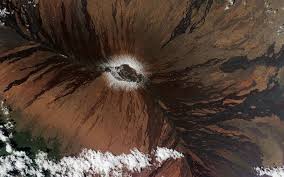
“The shape of the volcano is constantly changing and most of that change is due to the movement of underground magma in a magma pipe system made of magma reservoirs and channels,” said Christelle Wauthier, Professor in Geosciences and researcher at the Institute for Data and Computational Sciences (ICDS). at Penn State University quoted from his statement via Eurekalert , Sunday (18/10/2020).
Geoscience experts have used several methods to measure changes in land around volcanoes and other areas of seismic activity. However, all of these methods have limitations.
According to Jian Sun, a leading researcher who is pursuing a postdoctoral program in geoscience with the support of Dean’s Postdoc-Facilitated Innovation from the Collaboration Award from the College of Earth and Mineral Sciences.
Scientists, Jian said, can use earth stations, such as GPS or tiltmeters, to monitor possible ground movements due to volcanic activity . However, there are some problems with this land-based method. First, such instruments are expensive and need to be installed and maintained on site.
Second, according to him, the instrument will only provide ground motion measurements at the specific location where they are installed. Therefore, the spatial scope of these measurements is very limited.
Lack of data from satellites
Meanwhile, satellites and other forms of remote sensing can gather a lot of important data about volcanic activity for geoscientists. These devices are also, for the most part, far from eruption hazard and satellite imagery offers a wider spatial coverage of ground movement. However, this method also has drawbacks.
“We can monitor ground movements due to earthquakes or volcanoes using RADAR remote sensors, but even though we have access to a lot of remote sensing data, RADAR waves have to pass through the atmosphere in order to be recorded on the sensor,” said Jian.
The propagation path, he said, may also be affected by that atmosphere, especially if the climate is tropical with lots of water vapor and clouds that vary in space and time.
Kelebihan Deep Learning
According to the research, which was published in the Journal of Geophysical Research, the deep learning method they developed can take clear pieces of data.
In doing so, the system can complement the gaps in the data that contain noise and other gaps created by weather disturbances and other instruments. From there, the system can build a fairly accurate picture of the ground and its movements.
Using this deep learning method, scientists can gain valuable insights into ground motion, especially in areas with active volcanoes or earthquake and fault zones.
The program may also be able to spot potential warning signs, such as a sudden ground shift that might signal a volcanic eruption or an impending earthquake.
“It’s very important for areas close to active volcanoes, or near where earthquakes occur, to have the earliest possible warning that something might happen,” said Jian.