Source: photonics.com
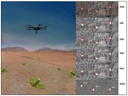
Researchers at Binghamton University, who previously developed a method for detecting “butterfly” land mines using low-cost, commercial drones equipped with multispectral and infrared cameras, are now focusing on automated detection of land mines using convolutional neural networks.
Nicknamed “butterfly” land mines for their small size and butterfly-like shape, PFM-1 land mines are extremely difficult to locate and clear due to their small size, low trigger mass, and a design that mostly excludes metal components, making them virtually invisible to metal detectors.
The researchers analyzed multispectral and thermal data sets collected by an automated unmanned aerial vehicle (UAV) survey system featuring scattered PFM-1-type land mines as test objects. To automate land mine detection, they relied on supervised learning algorithms using a faster regional-convolutional neural network (Faster R-CNN).
The RGB visible light Faster R-CNN demo yielded a 99.3% testing accuracy for a partially withheld testing set and a 71.5% testing accuracy for a completely withheld testing set. The researchers found that across multiple test environments, the use of cm-scale, accurate, georeferenced data sets paired with Faster R-CNN allowed for accurate automated detection of the test PFM-1 land mines. The researchers said that their detection and mapping techniques could be calibrated to other types of scatterable antipersonnel mines in future trials to aid demining initiatives. For example, they could be adapted to detect and map disturbed soil for improvised explosive devices (IEDs).
The researchers said that the use of CNN-based approaches to automate the detection and mapping of land mines is much faster than manually counting land mines from an orthoimage (an aerial image that has been geometrically corrected). Also, a CNN-based method is quantitative and reproducible, unlike ocular detection, which is subjective and prone to human error. CNN-based methods can be generalized to detect and map any objects with distinct sizes and shapes from any remotely sensed raster images.
“Rapid drone-assisted mapping and automated detection of scatterable minefields would assist in addressing the deadly legacy of widespread use of small scatterable land mines in recent armed conflicts,” professor Alek Nikulin said,