Source: geospatialworld.net
Los Angeles based TipTags, announced it has launched a mobile map-based system designed to enable ANYONE to create, share and access hyper-local information about navigating the post-COVID-19 world in hurricanes and other potential emergencies. The goal is to provide risk-mitigation & increased awareness through transparency, placing potentially life-saving information in the hands of local Communities.
Despite stay-at-home orders, neighbors now have a way to keep each other informed about pandemic related topics such as testing, local outbreaks and PPE availability. With real-time, to-the-door accuracy, anyone can share first-hand knowledge about their local situation in a visual, map-based application using text, photos and links.
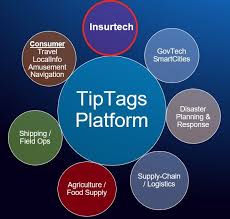
Originally created for NATO working with Harvard University researchers, TipTags created a collaborative crisis management system for use in the field to capture, preserve and share real-time, mission-critical data in conflict zones.
“While we weren’t planning a Community release of our app at this time, we recognized the urgency around the lack of reliable, real-time COVID-19 information, especially mapped at the neighborhood level.”, says TipTags CEO Tim Roberts. “This was a call-to-action for our team, knowing that our platform could help bring people together and reduce anxieties.”
Citizens, First-Responders, Government officials and Companies share the same dilemma, they have a hard time getting reliable, real-time data from human sources, and information is often siloed or difficult to interpret. TipTags allows users to access human intelligence directly from those who have the first-hand knowledge of conditions.
“We are also worried about Hurricane, Fire and Tornado season and the potential for disaster-forced evacuations to fuel any potential second-wave of the coronavirus.”, said TipTags CEO Tim Roberts. “Our ability to enable the gathering of and access to this granular-level information will help Healthcare providers, FEMA and Insurance companies to better address the needs of those displaced by disaster and exposed to increased coronavirus danger.”