Introduction
Nature can change in a single second. When storms, floods, or earthquakes strike, they leave chaos behind. Traditional forecasting tools often react too late. Communities suffer because people get little time to escape.
Today, smart technology changes this reality. By using advanced tools found at AIUniverse, researchers can see danger coming long before it hits land. Computers process massive amounts of weather data in real time. This means lives get saved and towns stay safe.
We face a new era of safety. Machine learning spots patterns that human eyes miss. Let us explore how smart tech protects our world.
The Core Science Behind Weather Modeling
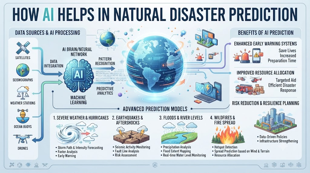
Weather modeling used to rely on slow computers. Old systems took hours to run basic calculations. Storms move fast, so every minute matters. Today, modern models run at incredible speeds. They look at wind speed, air pressure, and ocean warmth all at once.
Computers learn from past disasters. When a hurricane forms, the system checks old storms with similar traits. It predicts the exact path with high accuracy. You get clear forecasts days in advance. This gives local teams enough time to prepare sandbags and plan safe routes.
Why Speed Matters in Emergency Alerts
When a disaster happens, communication is key. Delayed warnings cause panic and confusion. AI speeds up the entire warning pipeline. Sensors on the ground feed live data to central servers. The system analyzes the data instantly.
Sirens and mobile alerts trigger automatically. People receive evacuation notices right on their phones. There is no waiting for human approval during late hours. Fast alerts reduce injuries and property damage. Every second saved keeps families out of harm’s way.
Understanding Seismic Activity With Machine Learning
Earthquakes strike without warning. The ground shakes violently, destroying homes and roads. While we cannot stop earthquakes, we can detect them early. Seismic sensors pick up tiny underground tremors. AI models analyze these tiny shifts instantly.
If a major quake starts deep underground, sensors notice the primary wave. This wave travels faster than the destructive secondary wave. The system sends an alert across the city within milliseconds. Trains stop automatically, and gas lines shut down. You get crucial seconds to drop, cover, and hold on.
Flood Forecasting and River Monitoring
Heavy rain turns quiet rivers into raging monsters. Flash floods sweep away cars and submerge neighborhoods. Water levels rise faster than anyone expects. Smart river monitors track rainfall and soil saturation continuously.
If soil cannot absorb more water, the system triggers a flood warning. Local authorities receive exact maps showing which streets will flood first. Rescuers place barriers before water reaches homes. You stay dry because technology warns you before the river spills over banks.
Real-World Case Studies in Disaster Prediction
- Case 1: Coastal sensors detected unusual wave patterns during a pacific storm. The AI system predicted a massive storm surge three hours early. Local teams evacuated the beach towns safely.
- Case 2: Mountain sensors tracked heavy snow melt and soil movement. An automated alert warned villagers of an impending landslide. Families moved uphill before tons of mud slid down.
- Case 3: A rural farming community faced severe drought conditions. Smart crop monitors predicted water shortages weeks ahead. Farmers saved their crops by shifting to efficient drip irrigation.
- Case 4: Urban weather networks tracked a sudden drop in air pressure over the city center. The system flagged a forming tornado and sounded sirens two minutes prior. Residents rushed to basements and avoided tragedy.
- Case 5: River gauge networks noticed rapid water accumulation after days of relentless rain. Automated gates opened to release excess water safely. Downstream towns avoided catastrophic flooding entirely.
- Case 6: Seismic monitors in a busy metropolitan zone detected minor foreshocks. The early warning system cut power to the subway grid. Trains stopped smoothly before the main tremor hit.
- Case 7: Forest rangers used thermal imaging drones powered by smart software. The system spotted a hidden campfire ember in dry brush. Crews extinguished the spark before a wildfire started.
- Case 8: Island communities relied on ocean temperature feeds to track tropical depressions. The model predicted landfall location with extreme precision. Emergency supplies arrived days before the storm hit.
- Case 9: Volcanic sensors picked up unusual gas emissions and ground swelling. The alert system declared a red zone evacuation. Residents left the area safely before the eruption occurred.
- Case 10: Utility companies monitored wind stress on overhead power lines. The predictive software flagged vulnerable poles during a gale. Crews repaired the weak spots before power lines snapped.
Comparing Traditional Methods vs. AI Systems
| Feature | Traditional Methods | AI-Powered Systems |
| Processing Speed | Slow, takes hours | Instant, real-time |
| Accuracy | Moderate, high error rate | High, learns from data |
| Alert Time | Minutes before impact | Hours or days before impact |
| Data Handling | Limited data sources | Millions of data points |
| Human Effort | High manual supervision | Automated monitoring |
Common Mistakes and Pitfalls
- Mistake 1: Relying only on old weather reports. Solution: Always use real-time sensor streams for current updates.
- Mistake 2: Ignoring local topography data. Solution: Include elevation maps so models understand regional water flow.
- Mistake 3: Failing to test backup power supplies. Solution: Install solar backups so sensors stay active during blackouts.
- Mistake 4: Overlooking false alarm rates. Solution: Tune confidence thresholds to reduce unnecessary panic.
- Mistake 5: Skipping regular sensor maintenance. Solution: Schedule monthly checks to clean and calibrate field devices.
- Mistake 6: Using complex jargon in public alerts. Solution: Write clear, simple warnings that everyone understands instantly.
- Mistake 7: Not training local staff on new tools. Solution: Conduct regular workshops for emergency response teams.
- Mistake 8: Isolating data in separate departments. Solution: Share weather and seismic feeds across all public safety agencies.
- Mistake 9: Ignoring community feedback. Solution: Listen to local residents to improve evacuation route maps.
- Mistake 10: Neglecting software security updates. Solution: Apply regular patches to protect forecasting networks from hackers.
Step-by-Step Implementation Roadmap
- Assess local weather risks and identify common natural hazards in your region.
- Install modern IoT weather sensors, rain gauges, and seismic monitors in key zones.
- Connect all field devices to a secure cloud-based data collection platform.
- Integrate advanced machine learning models to analyze incoming environmental data.
- Set up automated alert triggers for rapid public notification during emergencies.
- Partner with local emergency services to test communication channels regularly.
- Create simple, clear evacuation maps and share them with community members.
- Train local response teams on how to interpret real-time predictive dashboards.
- Monitor system performance during minor weather events to fine-tune accuracy.
- Review and update software protocols annually to incorporate newer safety features.
Frequently Asked Questions
1. How does AI predict natural disasters?
It analyzes past weather data, seismic activity, and live sensor feeds to spot warning signs early.
2. Can AI stop earthquakes from happening?
No, it cannot stop natural events, but it provides early warnings to keep people safe.
3. How fast do smart weather alerts arrive?
Alerts arrive in real time, often giving communities minutes to hours of advance notice.
4. Are these systems expensive to set up?
Initial setup requires investment, but long-term savings from prevented damage outweigh costs.
5. Do I need special equipment to receive alerts?
No, standard mobile phones receive emergency broadcast alerts directly from local authorities.
6. Can small towns use this technology?
Yes, scalable cloud systems allow rural towns to adopt modern disaster prediction tools easily.
7. How accurate are machine learning forecasts?
Accuracy improves constantly as models process more historical and live environmental data.
8. What happens if the internet goes down?
Local field units use satellite backups and local storage to keep functioning during outages.
9. How do rivers get monitored for floods?
Sensors measure water height and flow speed continuously and send data to central servers.
10. What is the first step to improve safety?
Audit existing emergency plans and upgrade outdated weather monitoring sensors in your area.
Final Recommendation and Next Steps
Protecting your community requires proactive planning and modern tools. Do not wait for the next storm to test your safety measures. Begin by auditing your local emergency response readiness today.
Invest in smart monitoring sensors and reliable alert networks. Share safety guides with your neighbors and family members. When we embrace smart prediction technology, we build stronger, safer communities for everyone.